
June 2026
Stormy Weather – the Great Flood of 1938
The rumblings about an El Niño across climate forecast circles were confirmed by a NOAA announcement on June 11th [2026], stating that the phenomenon has developed in the eastern tropical Pacific and will determine the pattern of weather for the remainder of this year and beyond. People are suggesting that this year, a “Super El Niño” – a set of extraordinary conditions – might multiply the effects of our weather in the seasons to come. The El Niño-Southern Oscillation, “ENSO,” is a vast pool of warmer water formed at the surface of the central and eastern equitorial Pacific Ocean that affects currents in the atmosphere above and well beyond its spread. Rotating air currents push ocean moisture toward the western coasts of the Americas. In Southern California, a Super El Niño could “supercharge” the usual summer high temperatures and in winter, the effects might include strong atmospheric-river storms bringing the risk of flooding, higher tides and coastal erosion, a replenishment of water reserves in man-built lakes and reservoirs and a reduction in the risk of brushfires (only to increase in later years with the rain-stimulated growth in plant material).
As early as 1892, Peruvian sailors recognized strong, warm southerly ocean currents in the offshore Pacific which returned in a multi-year cycle. They named the phenomenon for (in Spanish) “the Boy,” because it appeared around the Christmas season. It has been less than sixty years since researchers first discovered some of the climate mechanisms that drive ENSO. As we have gained knowledge, predictions about its timing and its effects have gradually become more sophisticated.
As of this month, NOAA is predicting a 82% chance of a strong El Niño this year and a 50% chance of a “Super El Niño.” While there have been 27 El Niño events since 1950, only five are considered “Super”, the last occurring in 2015-16. (Since their strongest effects occur in winter, they are labelled with a two year designation) They also occurred in 1972-73, 1982-83, 1991-92, and 1997-98. The winters of 1877-78 and 1888-89 are now regarded as Super El Niños, based on a review of their records.
The topography of Southern California makes the area naturally vulnerable to flash flooding. Coastal plains are walled off from the interior by steeply-sloped mountain ranges that both run parallel to the shoreline and transverse to it. [22 peaks in Los Angeles County alone are higher than Mount Mitchell, NC – at 6,684 ft, the highest peak in the eastern US]. Moisture-laden air above the Pacific is blown onshore by circulation around low pressure cells and even more strongly, by atmospheric-river storm systems driven by the Jet Stream. As this air is pushed up our slopes, it meets cooler air at higher elevations, causing water vapor to condense, triggering rainfall. Summer heat-hardened surfaces make the dry soil resistant to absorbing the first onslaught of showers. The
steep slopes accelerate runoff to combine in fast-moving walls of water flooding the flatter terrain below.
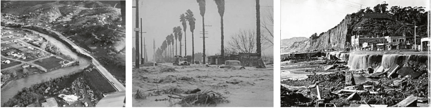
Early in the nineteenth century, floods are known to have altered the outlet of the Los Angeles River from the Santa Monica Bay, near Ballona Creek, to San Pedro Bay. The outflow of the Santa Ana River was moved several miles after floods in 1825. Storms delivered even larger volumes of water to the riverbeds and streams of Southern California in the Great Flood of 1862, but there were less men and their works to devastate then. Los Angeles was populated by about 4,400 souls within an area of about 44 acres. In the 1862 flood, the San Gabriel River, which had flowed into the Los Angeles River, altered course to empty into the Pacific at Los Alamitos.
It is, after all, the human cost of storms, floods, landslides and fires that brings them to the center of our attention. In a sleepy pueblo of a few thousand residents, people might pause in crossing the maìn road to look up at clouds of smoke trailing from the distant blue hillsides and marvel. But when those hillsides are covered side-by-side with family homes, the smoke that sweeps across them strikes fear into the entrails of the observers (“that could be my house!”). The same is true of houses toppled over an edge, sliding downward to destruction on a great field of land that, moments before, had been a hillside or residences torn from their foundations by a rushing current and carried seaward by ragged, muddy waters
Though the winter of 1937-38 is not considered to be a Super El Niño event, a series of heavy storms, culminating in a pair from February 27 through March 3, 1938, brought legendary devastation to Southern California. By then, Los Angeles covered 288 square miles and was home to about 1.3 million people, with twice that number living within the County. 11 inches of rain fell on downtown LA in that five day period. The rainfall collected in the watersheds and tributaries of our three major rivers and rushed toward the Pacific, rising above the river banks as the volume increased. Southern Californians had gotten the message about flooding in a region with a “Mediterranean” climate, but this was a “50-year flood,” and though some defenses were in place or being built, they weren’t ready.
Rocks, boulders, brush, trees and the debris of human habitation swept down the canyons and streams into the channels of the rivers, joining thousands of acre-feet of mud and water. Where the surrounding land was lower, it spread beyond their banks.
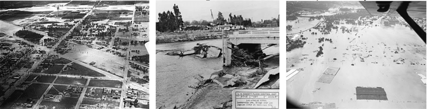
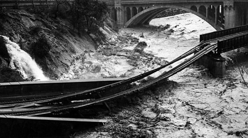
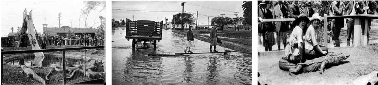
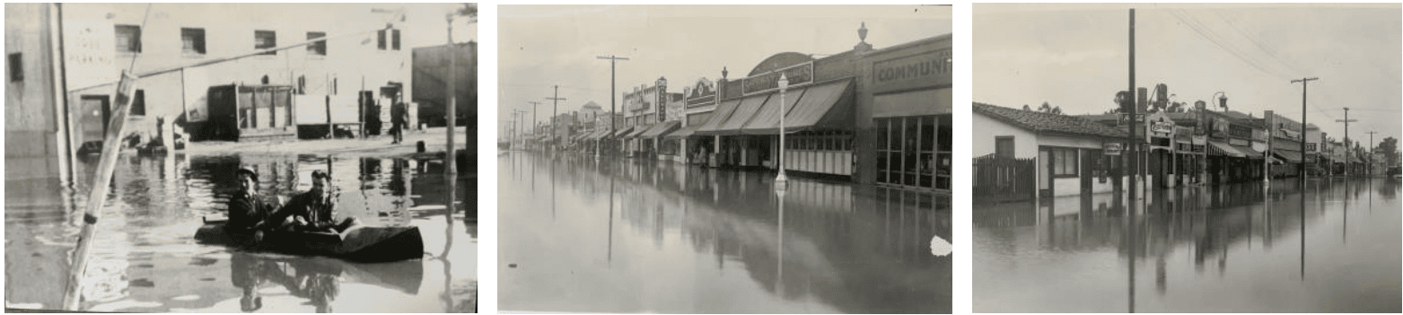
The low-lying San Fernando Valley took the brunt of flooding from the Los Angeles River, particularly the eastern end, where communities had been built up since the 1920s. The Barham Blvd bridge crossing the Cahuenga pass was washed away and several buildings on the Warner Bros. Studio lot were destroyed. Five people died when spans of the Lankershim Blvd bridge collapsed at Universal City. Inmates of the Los Angeles Alligator Farm, a popular public attraction in Lincoln Heights, escaped from their captivity.
The Big Tujunga Wash was filled to the depth of 6 ft, isolating adults and children at the Sheriff’s Boy’s Club Camp in the canyon. Parcels of food were dropped by plane to tide them over until rescue could be effected. The partially completed Big Tujunga Dam protected the Sunland, Tujunga, North Hollywood and Glendale communities below.
Upslope, the mountains were not spared from destruction: two Civilian Conservation Corps camps in the Angeles National Forest were washed away. In the High Desert, Palmdale was flooded, there was damage in Victorville and Barstow and the eastbound tracks of the Santa Fe Railway were cut off. The Southern Pacific mainline route north from Los Angeles to the rest of the State was closed at the Tehachapi Pass for two weeks. Operators had to use short wave radio to report that no damage to the Metropolitan Aqueduct (the MWD aqueduct connecting LA to the Colorado River) had been observed.
Floodwaters flowed onward to devastate Compton and Long Beach. To the west, Venice became an unintended larger replica of its namesake as high water in Ballona Creek drained into Santa Monica Bay. A total of 108,000 acres were flooded in greater Los Angeles.
In the watershed of the San Gabriel River and its downstream Valley, the torrent overtopped an emergency spillway at the site of the San Gabriel Dam, then under construction, and spread across the Valley floor. Four spans of a Pacific Electric Railway bridge connecting Monrovia and Glendora were washed away. Most of the service on the vast “Red Car” network was down for three weeks. A major highway project under construction, linking the San Gabriel Valley to Wrightwood, was damaged beyond repair and abandoned, leaving the notorious “Bridge to Nowhere” standing near
Heaton Flats.
In San Bernardino County, many houses and power stations were destroyed. Eight people were thought to be drowned by Friday, March 5th, once the storm had passed. Three hundred more were trapped at Camp Baldy. A party sent to rescue survivors in San Antonio Canyon was blocked by flows of deep mud. Washouts and slides interrupted the long east-west route of Foothill Blvd at so many places, it was impassable.
Nonetheless, LA and San Berdoo were “lucky” compared to Riverside and Orange Counties – the hardest hit of the region.
In Riverside County, silt covered lands flooded by the Santa Ana River. The area was searched for bodies after the storm moved farther on. Motorists who were marooned by deep water cutting off sections of Mission Blvd were later swept away. A young man in Corona was struck by lightning and killed. Palm Springs was cut off by floodwaters of the Whitewater River. Hundreds of Hollywood celebrities and wealthy society figures were stranded. The owner of the Desert Inn chartered a plane to fly in fresh milk for the local schoolchildren and supplies for vacationers. The City of Riverside was without power for ten hours.
On March 3rd, the flood rushed down the Santa Ana Canyon toward Orange County and burst through dikes built to contain the River, at some points forming a 15 foot-high wall of water. At 2:00 a.m., it washed away Atwood, a small community north of Placentia, populated mainly by Mexican agricultural workers. 43 lives were lost. Placentia police tried to warn their counterparts in downstream Anaheim, but the telephone lines were already down. By early morning, Fullerton and Anaheim were standing in a lake, 6 ft deep, that lasted for several weeks. Before noon, Buena Park was engulfed. 182,000 acres of Orange County were flooded – essentially, a lake stretching from Yorba Linda to Newport Beach, 15 ft deep at some points. Destruction stretched northward along the coast to Los Alamitos. 115 people died.
But the flooding wasn’t confined to the devastated areas of Southern California. It was the result of much more rainfall in a much shorter period than the ground could absorb or
the slope could carry away. Across the region, rain pooled where it had always pooled before the first human footprint was made in the mud. Studies have shown that our coastal areas, including the South Bay, were peppered with seasonal ponds and lakes created by the winter rains – which persisted until the summers dried them up (consider Madrona Marsh).
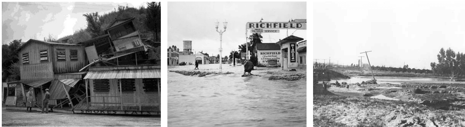
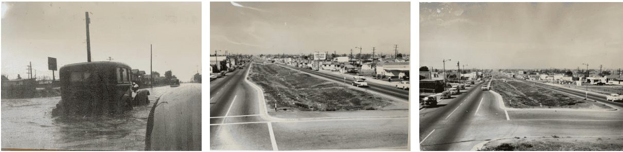
In Hawthorne, for blocks around the original center of the City, at Hawthorne Blvd and Broadway, the streets became a navigable lake – at least for publicity photos, delighted kids, inconvenienced motorists, pedestrians and unfortunate business owners. The Post Office, at that time located in a building on the north side of Broadway at 138 W., was moved to a building on Acacia Ave, to keep the mail and postal workers dry. In the Postwar period, the City undertook a years-long program of major public works to upgrade infrastructure and facilities of all types. It included a storm drain system built in the early 1950s – in coordination with Los Angeles County flood control projects – to keep Hawthornians high and dry. Work started on Broadway in October, 1954 and thereafter, citizens could traverse the old town center reliably dryshod. In some places, the center strip of Hawthorne Blvd, once occupied by streetcar tracks, was regraded to create a long series of even ditches, connected by culverts where streets crossed the thoroughfare between the northbound and southbound lanes, on level grade. Ultimately, storm drains that could handle runoff from the pavement were installed along the outer curbs, the depressions were filled in and lanes were added to the Boulevard
In the aftermath of the 1938 flood, railroad-, bus- and air travel, telephone- and telegraph services to and from Los Angeles were disrupted for five days. More than 3,700 people were made homeless in LA and Orange Counties. 1,500 homes were declared uninhabitable. A break in transmission lines from Hoover Dam created widespread electric power outages. Water and gas services were also interrupted. Hundreds of detours were set up around damaged roads, making travel difficult. Schools were closed for two days. But LA County’s partially-completed flood control system had prevented an even greater loss of life and damage to property. Southern Californians took the hint.
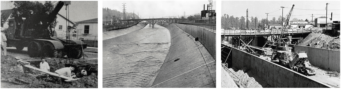
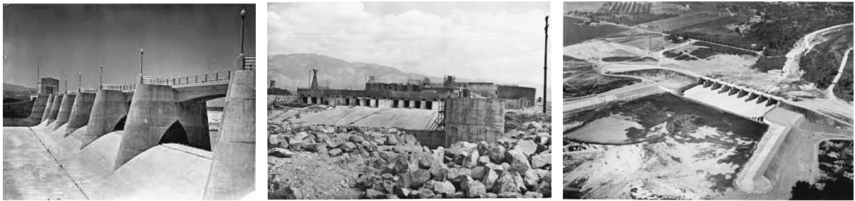
A gigantic twenty-year project to control the Los Angeles River was begun, led, in part, by the US Army Corps of Engineers. Large dams were completed: Sepulveda at Van Nuys in 1941, Santa Fe at Irwindale in 1949 and the Whittier Narrows in 1956. Gradually, 51 miles of the Los Angeles River and 278 miles of streams were encased in beds and high walls of stout concrete. The other counties followed LA’s lead. The system was tested by major rainfall from a storm in February, 1969. Glendora suffered extensive damage and lives were lost in Silverado Canyon in Orange County, but the system held back the waters.
The renown of Southern California as a warm, dry, favored place on our planet has drawn legions of curious travelers to visit here over the centuries, many to remain and join us in the pleasures of our homeland — but we have a secret, a lesson to be learned by newcomers about our little Eden: 🎵”It never rains in California, but girl, don’t they warn ya . . . It pours, man, it pours.”
So, get ready for our weather to play a leading role in your daily life this year and next. Before it’s Summer, clean up those table- and ceiling fans. Find that shady hat for outdoors. Stay hydrated. Before it’s Fall, go shopping for a good umbrella. Make sure your raingear is in good condition, especially your rubber boots. Think about keeping a life belt handy. Clean the leaves out of your gutters and deal with those leaky roofs. Know the low spots around your home and along your usual routes. You might check your nearest storm drain openings, clear away the litter or give the City a heads up. If you’ve got the room, build an Ark before Winter. We humans have been living in Southern California for at least 10,500 years. We’ve learned what to do.